
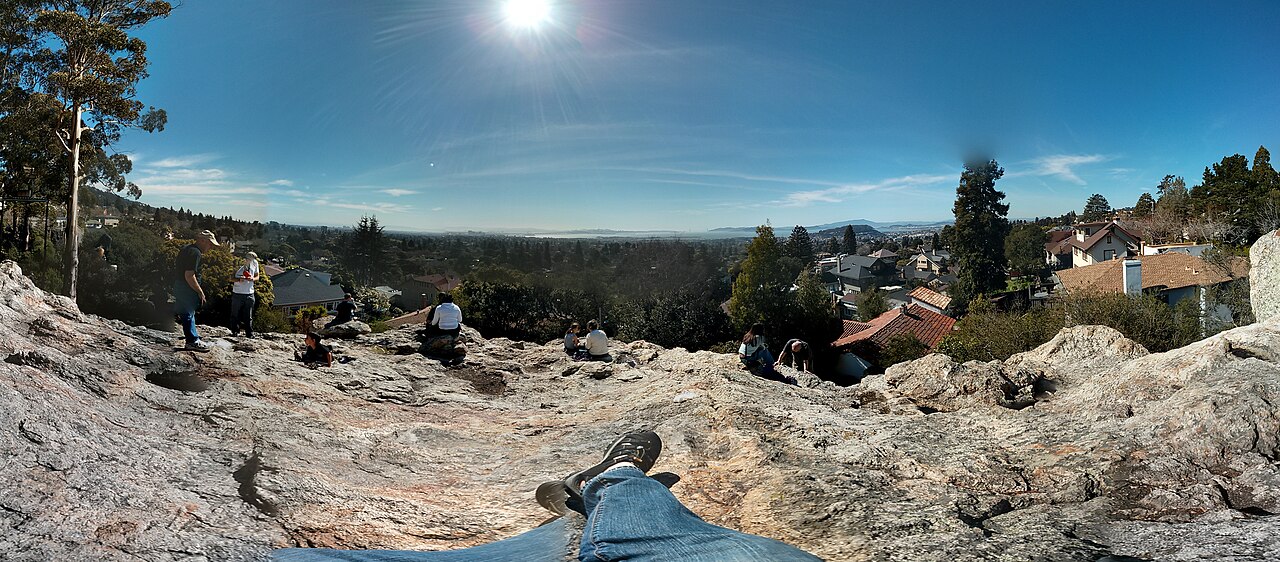
What makes Northbrae distinctive? In this largely residential part of North Berkeley, rock formations rise among homes, public paths connect streets, and older architecture responds to the hillside setting. Indian Rock is the best-known place to take in that relationship on a larger scale, with stone steps leading to an outlook over the Bay.
North Berkeley · East Bay
Northbrae and Indian Rock: Homes, Stairways and Rock Parks

Solano Avenue and the Hopkins Street shopping area sit along the neighborhood's edges. Between those commercial stops, the homes, gardens, stairways and small rock parks give a walk its own focus.
My local perspective
What I love about Northbrae is the way its older homes complement the natural landscape. Little staircases run beside houses, and rocks jut out behind them.
Indian Rock is still one of my favorite places in the East Bay to take a break. I went there often in high school and the years afterward, and I still go from time to time to enjoy the views.
A neighborhood designed around its terrain
The Berkeley Historical Plaque Project dates the Northbrae subdivision to 1907. Its account describes landscape architect R. E. Mansell's curving streets and path network, with the circle, stairways, benches and street-marker pillars designed by John Galen Howard.
These details help explain why the area rewards looking beyond individual houses. A stone street marker, a staircase and a curving road are parts of a larger design. The rock formations also remain visible, in public parks and beside homes.
The American Planning Association's 2011 profile identifies Craftsman and California bungalows as characteristic architecture and describes houses built beside the local volcanic outcrops. The relationship between buildings and rock gives the streets a character you can notice even without visiting a park.
Indian Rock: steps, climbing and the Bay outlook
Indian Rock Park, at 950 Indian Rock Avenue, occupies land on both sides of the street. On the east side, steps carved into the main rock lead upward to the outlook. Other parts of the park have smaller rocks, benches and green spaces.
The park supports both people coming for the view and climbers using its rock faces. Those are different activities: you can enjoy the setting without treating it as a climbing outing. The stone steps and uneven surfaces are part of the experience, so check the City's visitor information if stairs or footing affect your plans.
Other rock parks have their own character
Nearby Mortar Rock Park, at 901 Indian Rock Avenue, has rock formations in a more shaded setting. Bouldering is a prominent activity, while paths and seating offer another way to spend time around the rocks. It is a smaller, different setting from Indian Rock's main outlook.
Contra Costa Rock Park, at 869-A Contra Costa Avenue, adds another small public rock park among residential streets. The City describes stone steps and an outlook, with uneven surfaces on the way up. These pockets of public landscape help explain how natural formations remain part of the neighborhood's everyday surroundings.
Public paths make the street pattern more interesting
Northbrae's stairways were part of the original neighborhood plan, with connections to the former commuter rail system. The historical plaque account connects Fountain Walk to a former station near Marin Circle, showing how pedestrian routes once served daily travel.
Today, the Berkeley Path Wanderers Association maintains maps, path information and walking-event listings. Its resources help distinguish named public routes from the steps that serve individual homes. Check current conditions and keep to designated public paths; residential stairways and rocks beside homes may be private.
The small details are worth noticing from public space: stonework, the curve of a street, a staircase between levels and the way buildings sit beside rock. A visit need not revolve around a single overlook.
Marin Circle adds a different kind of landmark
At Marin Circle, the fountain and surrounding balustrades give the neighborhood a formal designed space alongside its natural rocks. The Historical Plaque Project records the original fountain's 1911 dedication and the replacement fountain's 1996 rededication after a community restoration campaign.
The fountain is a streetscape landmark to appreciate from the surrounding public walkways. It sits within a traffic circle, so use the designated pedestrian routes when exploring nearby.
Food shopping along the edges
On the Hopkins Street side, Monterey Market focuses on produce and groceries. Toward Solano Avenue, restaurants, coffee and other shops offer a different commercial setting. These edges provide practical stops around a neighborhood whose interior is largely residential.
For a broader food outing, the North Berkeley guide covers North Shattuck's businesses. North Shattuck and Northbrae are distinct places within the wider North Berkeley area.
The Solano Avenue guide takes a closer look at the cafés, restaurants and shops along the Albany–Berkeley corridor.
A nearby Sunday farmers' market
The Kensington Farmers' Market operates Sundays, 9 a.m.–2 p.m., at Colusa Circle in Kensington. The County lists it as year-round. It is a nearby alternative in another community, rather than a market inside Northbrae.
Market details checked November 4, 2026. Times are local; check the operator for holiday closures or schedule changes.
The Colusa Circle guide covers that market and the surrounding Kensington businesses.
Explore North Berkeley further
Return to the North Berkeley overview or the Berkeley city guide to place these parks and streets in the wider city. If Northbrae interests you as a place to live, we can talk about what you're looking for.
Sources & local information
Business and visitor details can change. Follow the original sources for current information.
- Berkeley Historical Plaque Project: Northbrae Public Improvements, 2003 plaque account
- American Planning Association: Northbrae, 2011 historical design profile
- City of Berkeley: Indian Rock Park
- City of Berkeley: Mortar Rock Park
- City of Berkeley: Contra Costa Rock Park
- Berkeley Path Wanderers Association: Maps and current path information
- Monterey Market: Produce and groceries
- Kensington Farmers' Market: Sunday schedule
- Contra Costa County: Market seasons and schedules